Roggiano Gravina night lights from space
Night Light of Roggiano Gravina (Calabria) from space (Italy) Src. Average luminocity for 10x10km area is 10.4172% and for 50x50km: 10.4606%.
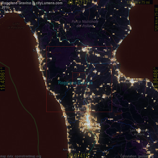
Analysis of Roggiano Gravina night lights 2016
Square area 10x10 km:
 0%
0%90-99
1.14%80-89
2.11%70-79
0.65%60-69
1.46%50-59
2.76%40-49
0.32%30-39
1.95%20-29
1.79%10-19
1.14%0-9
86.69%Square area 50x50 km:
0.25%90-99
0.89%80-89
1.55%70-79
1.2%60-69
1.43%50-59
2.16%40-49
1.15%30-39
2.15%20-29
2.56%10-19
6.47%0-9
80.2%Clear (daylight) street map image can be seen on geolist.org.
Map coordinates:
40° 9' 26.5" North, 15° 27' 31" East
39° 37' 4.3" North, 16° 9' 42.2" East
39° 4' 26.8" North, 16° 51' 53.5" East
Some cities around Roggiano Gravina sort by population:
• Castrovillari
22.3 km =13.9 mi,  8°
8°
• Corigliano Scalo
30.2 km =18.8 mi,  88°
88°
• Paola
30.3 km =18.8 mi,  200°
200°
• Cassano Allo Ionio
23.1 km =14.4 mi,  37°
37°
• Acri
23.5 km =14.6 mi,  125°
125°
• Spezzano Albanese
13.8 km =8.6 mi,  65°
65°
• Belvedere Marittimo
25.7 km =16 mi,  270°
270°
• Bisignano
16 km =9.9 mi,  140°
140°
2523591 (p: 5,693)
Sources (retrieved 2019-11-25):
» Earth at Night: Flat Maps 2012, 2016