Senise night lights from space
Night Light of Senise (Basilicate) from space (Italy) Src. Average luminocity for 10x10km area is 6.7175% and for 50x50km: 2.8498%.
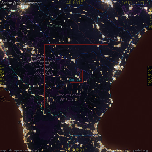
Analysis of Senise night lights 2016
Square area 10x10 km:
 0%
0%90-99
0.97%80-89
1.46%70-79
1.14%60-69
2.76%50-59
0.81%40-49
0%30-39
0%20-29
0%10-19
0%0-9
92.86%Square area 50x50 km:
0.07%90-99
0.4%80-89
0.58%70-79
0.41%60-69
0.53%50-59
0.37%40-49
0.43%30-39
0.31%20-29
0.53%10-19
0.15%0-9
96.22%Clear (daylight) street map image can be seen on geolist.org.
Map coordinates:
40° 40' 53.4" North, 15° 35' 8" East
40° 8' 46.2" North, 16° 17' 19.2" East
39° 36' 23.7" North, 16° 59' 30.5" East
Some cities around Senise sort by population:
• Castrovillari
37.4 km =23.2 mi,  191°
191°
• Policoro
33.9 km =21.1 mi,  77°
77°
• Cassano Allo Ionio
40.7 km =25.3 mi,  175°
175°
• Marconia
41.6 km =25.8 mi,  54°
54°
• Ferrandina
41.8 km =26 mi,  19°
19°
• Trebisacce
37 km =23 mi,  145°
145°
• Montalbano Jonico
28.5 km =17.7 mi,  56°
56°
• Pisticci
35.5 km =22.1 mi,  40°
40°
3166737 (p: 6,243)
Sources (retrieved 2019-11-25):
» Earth at Night: Flat Maps 2012, 2016