Capua night lights from space
Night Light of Capua (Campania) from space (Italy) Src. Average luminocity for 10x10km area is 52.2825% and for 50x50km: 39.6137%.
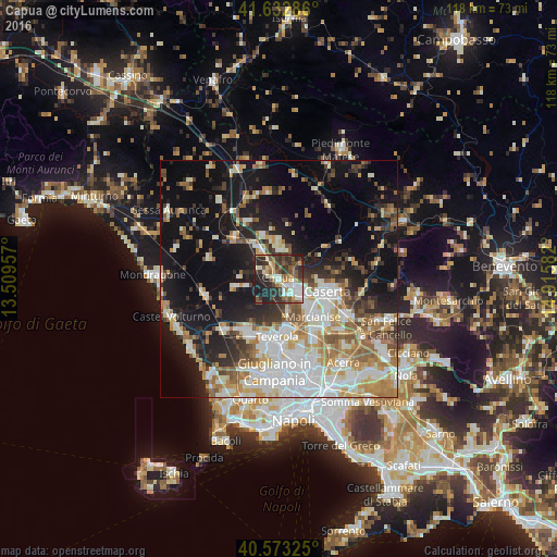
Analysis of Capua night lights 2016
Square area 10x10 km:
 8.93%
8.93%90-99
8.44%80-89
5.84%70-79
7.31%60-69
4.55%50-59
12.34%40-49
8.44%30-39
15.91%20-29
19.32%10-19
8.93%0-9
0%Square area 50x50 km:
8.35%90-99
8.92%80-89
3.88%70-79
5%60-69
5.44%50-59
5.2%40-49
3.69%30-39
4.4%20-29
7.81%10-19
21.21%0-9
26.09%Clear (daylight) street map image can be seen on geolist.org.
Map coordinates:
41° 37' 58.3" North, 13° 30' 34.5" East
41° 6' 18.7" North, 14° 12' 45.7" East
40° 34' 23.7" North, 14° 54' 57" East
Some cities around Capua sort by population:
• Santa Maria Capua Vetere
4.3 km =2.7 mi,  127°
127°
• Casagiove
9.1 km =5.7 mi,  114°
114°
• San Prisco
5.8 km =3.6 mi, 111°
• Macerata Campania
7.2 km =4.5 mi, 130°
• Casapulla
7.2 km =4.5 mi,  116°
116°
• Portico di Caserta
7.9 km =4.9 mi, 134°
• Curti
6.5 km =4 mi, 119°
• Vitulazio
6.4 km =4 mi,  0°
0°
3180601 (p: 15,438)
Sources (retrieved 2019-11-25):
» Earth at Night: Flat Maps 2012, 2016