Sparanise night lights from space
Night Light of Sparanise (Campania) from space (Italy) Src. Average luminocity for 10x10km area is 28.9675% and for 50x50km: 27.3649%.
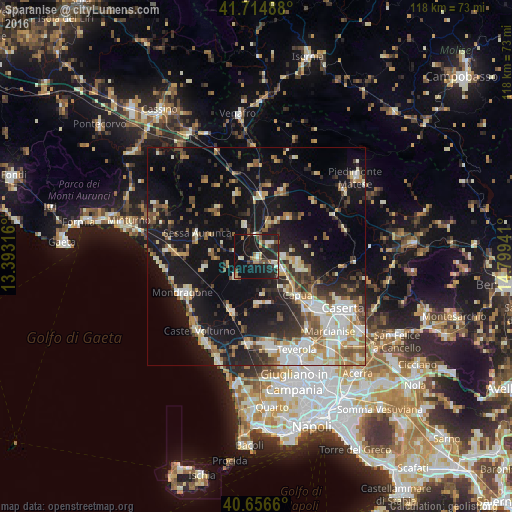
Analysis of Sparanise night lights 2016
Square area 10x10 km:
 2.92%
2.92%90-99
3.9%80-89
2.6%70-79
2.6%60-69
3.41%50-59
4.71%40-49
3.25%30-39
3.08%20-29
16.88%10-19
45.29%0-9
11.36%Square area 50x50 km:
3.65%90-99
5.66%80-89
2.81%70-79
2.9%60-69
3.31%50-59
3.9%40-49
3.17%30-39
3.79%20-29
6.93%10-19
23.96%0-9
39.93%Clear (daylight) street map image can be seen on geolist.org.
Map coordinates:
41° 42' 53.6" North, 13° 23' 35.4" East
41° 11' 16.4" North, 14° 5' 46.6" East
40° 39' 23.8" North, 14° 47' 57.9" East
Some cities around Sparanise sort by population:
• Capua
13.4 km =8.3 mi,  133°
133°
• Vitulazio
10.2 km =6.3 mi,  105°
105°
• Zuni
4.4 km =2.7 mi,  41°
41°
• Pignataro Maggiore
6.2 km =3.9 mi,  87°
87°
• Calvi Risorta
4.3 km =2.7 mi, 42°
• Grazzanise
10.9 km =6.8 mi,  178°
178°
• Sessa Aurunca
15.1 km =9.4 mi,  292°
292°
• Teano
7.5 km =4.7 mi,  340°
340°
3166301 (p: 7,175)
Sources (retrieved 2019-11-25):
» Earth at Night: Flat Maps 2012, 2016