Palmi night lights from space
Night Light of Palmi (Calabria) from space (Italy) Src. Average luminocity for 10x10km area is 26.869% and for 50x50km: 13.2228%.
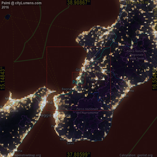
Analysis of Palmi night lights 2016
Square area 10x10 km:
 1.87%
1.87%90-99
3.06%80-89
5.78%70-79
1.7%60-69
3.91%50-59
4.25%40-49
2.55%30-39
3.91%20-29
5.1%10-19
42.18%0-9
25.68%Square area 50x50 km:
0.97%90-99
1.52%80-89
1.99%70-79
1.68%60-69
1.52%50-59
1.65%40-49
1.24%30-39
2.33%20-29
5.27%10-19
14.03%0-9
67.81%Clear (daylight) street map image can be seen on geolist.org.
Map coordinates:
38° 54' 31.2" North, 15° 8' 54.3" East
38° 21' 33.9" North, 15° 51' 5.6" East
37° 48' 21.6" North, 16° 33' 16.8" East
Some cities around Palmi sort by population:
• Gioia Tauro
8.3 km =5.2 mi,  28°
28°
• Villa San Giovanni
24.3 km =15.1 mi,  230°
230°
• Rosarno
18.1 km =11.2 mi,  38°
38°
• Taurianova
14.1 km =8.8 mi,  91°
91°
• Polistena
20 km =12.4 mi,  75°
75°
• Cittanova
19.8 km =12.3 mi, 91°
• Bagnara Calabra
8.9 km =5.5 mi,  206°
206°
• Cinque Frondi
21.2 km =13.2 mi,  72°
72°
2523902 (p: 18,556)
Sources (retrieved 2019-11-25):
» Earth at Night: Flat Maps 2012, 2016