Olginate night lights from space
Night Light of Olginate (Lombardy) from space (Italy) Src. Average luminocity for 10x10km area is 47.0565% and for 50x50km: 46.9015%.
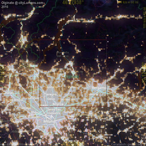
Analysis of Olginate night lights 2016
Square area 10x10 km:
 6.1%
6.1%90-99
6.99%80-89
3.72%70-79
4.02%60-69
4.76%50-59
7.44%40-49
19.49%30-39
25.74%20-29
10.27%10-19
10.27%0-9
1.19%Square area 50x50 km:
14.61%90-99
11.16%80-89
4.73%70-79
6.3%60-69
6.28%50-59
4.33%40-49
4.06%30-39
4.64%20-29
4.73%10-19
7.16%0-9
32.02%Clear (daylight) street map image can be seen on geolist.org.
Map coordinates:
46° 16' 45.8" North, 8° 42' 56.1" East
45° 47' 28.5" North, 9° 25' 7.3" East
45° 17' 55.8" North, 10° 7' 18.6" East
Some cities around Olginate sort by population:
• Lecco
7.4 km =4.6 mi,  346°
346°
• Calolziocorte
1.5 km =0.9 mi,  72°
72°
• Merate
11.4 km =7.1 mi,  179°
179°
• Valmadrera-Caserta
7.7 km =4.8 mi,  322°
322°
• Oggiono
5.5 km =3.4 mi,  270°
270°
• Olgiate Molgora
6.9 km =4.3 mi,  189°
189°
• Robbiate
11.5 km =7.1 mi,  172°
172°
• Barzanò
10.4 km =6.5 mi,  231°
231°
3172064 (p: 6,979)
Sources (retrieved 2019-11-25):
» Earth at Night: Flat Maps 2012, 2016