Oleggio night lights from space
Night Light of Oleggio (Piedmont) from space (Italy) Src. Average luminocity for 10x10km area is 26.7621% and for 50x50km: 40.1873%.
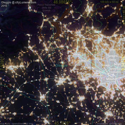
Analysis of Oleggio night lights 2016
Square area 10x10 km:
 0.15%
0.15%90-99
3.33%80-89
0.45%70-79
2.88%60-69
2.73%50-59
7.12%40-49
4.7%30-39
6.21%20-29
20.76%10-19
37.27%0-9
14.39%Square area 50x50 km:
6.8%90-99
8.23%80-89
3.67%70-79
4.8%60-69
6.3%50-59
6.15%40-49
5.81%30-39
6.74%20-29
11.27%10-19
19.59%0-9
20.63%Clear (daylight) street map image can be seen on geolist.org.
Map coordinates:
46° 5' 11.6" North, 7° 56' 20.4" East
45° 35' 48.3" North, 8° 38' 31.7" East
45° 6' 9.4" North, 9° 20' 42.9" East
Some cities around Oleggio sort by population:
• Somma Lombardo
10.8 km =6.7 mi,  28°
28°
• Lonate Pozzolo
8.6 km =5.3 mi,  93°
93°
• Cameri
10.7 km =6.6 mi,  171°
171°
• Bellinzago Novarese
3.1 km =1.9 mi,  178°
178°
• Turbigo
10.4 km =6.5 mi,  134°
134°
• Ferno
9.2 km =5.7 mi,  77°
77°
• Casorate Sempione
11.5 km =7.1 mi,  44°
44°
• Vanzaghello
11.1 km =6.9 mi,  99°
99°
3172079 (p: 12,655)
Sources (retrieved 2019-11-25):
» Earth at Night: Flat Maps 2012, 2016