Valguarnera Caropepe night lights from space
Night Light of Valguarnera Caropepe (Sicily) from space (Italy) Src. Average luminocity for 10x10km area is 5.0568% and for 50x50km: 5.7871%.
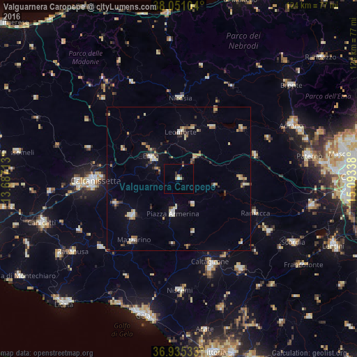
Analysis of Valguarnera Caropepe night lights 2016
Square area 10x10 km:
 0.32%
0.32%90-99
0.32%80-89
0.97%70-79
1.62%60-69
0%50-59
0%40-49
0%30-39
2.44%20-29
0.16%10-19
0%0-9
94.16%Square area 50x50 km:
0.59%90-99
0.61%80-89
1.02%70-79
0.65%60-69
0.72%50-59
0.63%40-49
0.54%30-39
1%20-29
0.6%10-19
1.27%0-9
92.37%Clear (daylight) street map image can be seen on geolist.org.
Map coordinates:
38° 3' 3.7" North, 13° 41' 13.7" East
37° 29' 43" North, 14° 23' 24.9" East
36° 56' 7.2" North, 15° 5' 36.2" East
Some cities around Valguarnera Caropepe sort by population:
• Enna
12.9 km =8 mi,  307°
307°
• Piazza Armerina
12.5 km =7.8 mi,  188°
188°
• Leonforte
16.3 km =10.1 mi,  2°
2°
• Barrafranca
21 km =13 mi,  231°
231°
• Mazzarino
26.8 km =16.7 mi,  216°
216°
• Agira
21.2 km =13.2 mi,  32°
32°
• Pietraperzia
23.9 km =14.9 mi,  249°
249°
• Mirabella Imbaccari
19.3 km =12 mi,  165°
165°
2522805 (p: 7,453)
Sources (retrieved 2019-11-25):
» Earth at Night: Flat Maps 2012, 2016