Montignoso night lights from space
Night Light of Montignoso (Tuscany) from space (Italy) Src. Average luminocity for 10x10km area is 46.9079% and for 50x50km: 16.0114%.
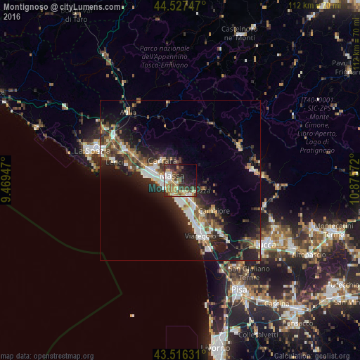
Analysis of Montignoso night lights 2016
Square area 10x10 km:
 5.71%
5.71%90-99
10.63%80-89
6.35%70-79
7.62%60-69
6.19%50-59
6.35%40-49
7.78%30-39
8.41%20-29
16.19%10-19
12.7%0-9
12.06%Square area 50x50 km:
2.34%90-99
2.95%80-89
1.44%70-79
1.56%60-69
1.66%50-59
2.45%40-49
2.65%30-39
2.89%20-29
6.29%10-19
10.75%0-9
65.04%Clear (daylight) street map image can be seen on geolist.org.
Map coordinates:
44° 31' 38.9" North, 9° 28' 10.1" East
44° 1' 26.6" North, 10° 10' 21.3" East
43° 30' 58.7" North, 10° 52' 32.6" East
Some cities around Montignoso sort by population:
• Massa
2.9 km =1.8 mi,  295°
295°
• Carrara
8.6 km =5.3 mi,  315°
315°
• Marina di Carrara
10.6 km =6.6 mi,  278°
278°
• Marina di Massa
5.7 km =3.5 mi,  246°
246°
• Pietrasanta
8.4 km =5.2 mi,  148°
148°
• Ripa-Pozzi-Querceta-Ponterosso
5.7 km =3.5 mi, 154°
• Capanne-Prato-Cinquale
3.3 km =2.1 mi,  203°
203°
• Forte dei Marmi
6.7 km =4.2 mi,  178°
178°
3172669 (p: 10,023)
Sources (retrieved 2019-11-25):
» Earth at Night: Flat Maps 2012, 2016