Capanne-Prato-Cinquale night lights from space
Night Light of Capanne-Prato-Cinquale (Tuscany) from space (Italy) Src. Average luminocity for 10x10km area is 59.4222% and for 50x50km: 16.4255%.
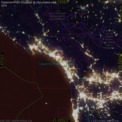
Analysis of Capanne-Prato-Cinquale night lights 2016
Square area 10x10 km:
 13.02%
90-99
18.41%80-89
6.83%70-79
7.62%60-69
6.83%50-59
5.24%40-49
3.49%30-39
4.92%20-29
20.95%10-19
11.27%0-9
1.43%Square area 50x50 km:
2.37%90-99
3.11%80-89
1.39%70-79
1.64%60-69
1.7%50-59
2.57%40-49
2.8%30-39
2.84%20-29
6.61%10-19
10.89%0-9
64.09%Clear (daylight) street map image can be seen on geolist.org.
Map coordinates:
44° 30' 3.1" North, 9° 27' 11.7" East
43° 59' 49.9" North, 10° 9' 22.9" East
43° 29' 21.2" North, 10° 51' 34.2" East
Some cities around Capanne-Prato-Cinquale sort by population:
• Massa
4.5 km =2.8 mi,  342°
342°
• Carrara
10.3 km =6.4 mi,  332°
332°
• Marina di Carrara
10.3 km =6.4 mi,  296°
296°
• Marina di Massa
4 km =2.5 mi,  280°
280°
• Pietrasanta
7.1 km =4.4 mi,  126°
126°
• Montignoso
3.3 km =2.1 mi,  23°
23°
• Ripa-Pozzi-Querceta-Ponterosso
4.3 km =2.7 mi,  119°
119°
• Forte dei Marmi
4 km =2.5 mi,  158°
158°
3178670 (p: 8,270)
Sources (retrieved 2019-11-25):
» Earth at Night: Flat Maps 2012, 2016