Castelfidardo night lights from space
Night Light of Castelfidardo (The Marches) from space (Italy) Src. Average luminocity for 10x10km area is 54.7762% and for 50x50km: 23.282%.
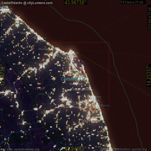
Analysis of Castelfidardo night lights 2016
Square area 10x10 km:
 7.62%
7.62%90-99
11.59%80-89
8.57%70-79
8.1%60-69
5.87%50-59
7.14%40-49
8.89%30-39
14.92%20-29
19.84%10-19
7.46%0-9
0%Square area 50x50 km:
3.42%90-99
4.91%80-89
1.97%70-79
2.51%60-69
2.09%50-59
2.81%40-49
3.15%30-39
3.4%20-29
9.7%10-19
20.91%0-9
45.14%Clear (daylight) street map image can be seen on geolist.org.
Map coordinates:
43° 58' 2.6" North, 12° 50' 50.4" East
43° 27' 33" North, 13° 33' 1.6" East
42° 56' 47.9" North, 14° 15' 12.9" East
Some cities around Castelfidardo sort by population:
• Ancona
15.5 km =9.6 mi,  345°
345°
• Osimo
6.2 km =3.9 mi,  297°
297°
• Recanati
6.2 km =3.9 mi,  177°
177°
• Porto Recanati
9.4 km =5.8 mi,  107°
107°
• Loreto
5.6 km =3.5 mi,  117°
117°
• Le Grazie di Ancona
16 km =9.9 mi, 349°
• Filottrano
16.3 km =10.1 mi,  260°
260°
• Camerano
7.6 km =4.7 mi,  1°
1°
3179697 (p: 14,892)
Sources (retrieved 2019-11-25):
» Earth at Night: Flat Maps 2012, 2016