Lavagna night lights from space
Night Light of Lavagna (Liguria) from space (Italy) Src. Average luminocity for 10x10km area is 35.8485% and for 50x50km: 6.3215%.
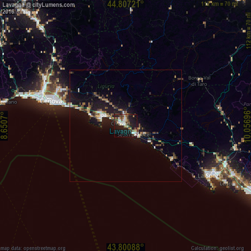
Analysis of Lavagna night lights 2016
Square area 10x10 km:
 5.61%
5.61%90-99
7.73%80-89
4.09%70-79
2.12%60-69
3.33%50-59
3.79%40-49
6.82%30-39
5.91%20-29
8.64%10-19
38.94%0-9
13.03%Square area 50x50 km:
0.57%90-99
0.88%80-89
0.49%70-79
0.44%60-69
0.88%50-59
0.9%40-49
1.26%30-39
1.08%20-29
1.37%10-19
7.92%0-9
84.21%Clear (daylight) street map image can be seen on geolist.org.
Map coordinates:
44° 48' 26" North, 8° 39' 2.5" East
44° 18' 22.3" North, 9° 21' 13.8" East
43° 48' 3.2" North, 10° 3' 25.1" East
Some cities around Lavagna sort by population:
• Genoa
34.3 km =21.3 mi,  288°
288°
• Rapallo
11.1 km =6.9 mi,  295°
295°
• Chiavari
2.8 km =1.7 mi, 297°
• Sestri Levante
5 km =3.1 mi,  137°
137°
• Recco
17.8 km =11.1 mi, 290°
• Santa Margherita Ligure
11.7 km =7.3 mi, 285°
• Borgo Val di Taro
38.7 km =24 mi,  58°
58°
• Casarza Ligure
8.3 km =5.2 mi,  117°
117°
3175024 (p: 11,455)
Sources (retrieved 2019-11-25):
» Earth at Night: Flat Maps 2012, 2016