Fregene night lights from space
Night Light of Fregene (Latium) from space (Italy) Src. Average luminocity for 10x10km area is 26.0175% and for 50x50km: 28.3622%.
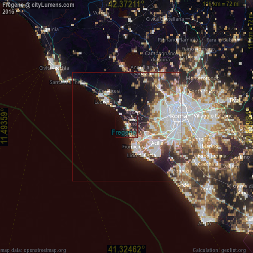
Analysis of Fregene night lights 2016
Square area 10x10 km:
 0.63%
0.63%90-99
5.24%80-89
2.86%70-79
1.9%60-69
3.17%50-59
4.76%40-49
3.65%30-39
4.6%20-29
14.13%10-19
27.78%0-9
31.27%Square area 50x50 km:
7.87%90-99
7.05%80-89
2.71%70-79
2.53%60-69
2.93%50-59
2.95%40-49
2.61%30-39
3.01%20-29
6.17%10-19
10.67%0-9
51.5%Clear (daylight) street map image can be seen on geolist.org.
Map coordinates:
42° 22' 19.6" North, 11° 29' 36.9" East
41° 51' 1.8" North, 12° 11' 48.2" East
41° 19' 28.6" North, 12° 53' 59.4" East
Some cities around Fregene sort by population:
• Acilia-Castel Fusano-Ostia Antica
14.7 km =9.1 mi,  131°
131°
• Lido di Ostia
14.7 km =9.1 mi,  153°
153°
• Fiumicino-Isola Sacra
9.4 km =5.8 mi,  159°
159°
• Ladispoli
15 km =9.3 mi,  317°
317°
• Casal Palocco
16.9 km =10.5 mi, 132°
• Cerveteri
17.9 km =11.1 mi,  330°
330°
• La Massimina-Casal Lumbroso
13.5 km =8.4 mi,  79°
79°
• Ara Nova
9.8 km =6.1 mi,  21°
21°
3176544 (p: 6,727)
Sources (retrieved 2019-11-25):
» Earth at Night: Flat Maps 2012, 2016