Ciriè night lights from space
Night Light of Ciriè (Piedmont) from space (Italy) Src. Average luminocity for 10x10km area is 43.5909% and for 50x50km: 32.4117%.
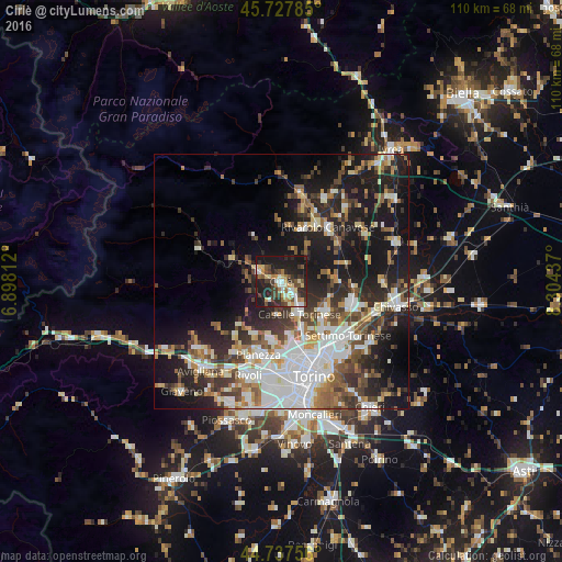
Analysis of Ciriè night lights 2016
Square area 10x10 km:
 6.36%
6.36%90-99
5.61%80-89
7.73%70-79
4.85%60-69
4.85%50-59
5%40-49
8.18%30-39
8.94%20-29
18.64%10-19
29.85%0-9
0%Square area 50x50 km:
6.97%90-99
6.77%80-89
2.71%70-79
3.29%60-69
3.58%50-59
4.64%40-49
4.65%30-39
5.07%20-29
8.99%10-19
19.44%0-9
33.9%Clear (daylight) street map image can be seen on geolist.org.
Map coordinates:
45° 43' 40.3" North, 6° 53' 53.2" East
45° 14' 5.5" North, 7° 36' 4.5" East
44° 44' 15.2" North, 8° 18' 15.7" East
Some cities around Ciriè sort by population:
• Venaria Reale
12.3 km =7.6 mi,  168°
168°
• Leini
10.6 km =6.6 mi,  123°
123°
• Caselle Torinese
7.5 km =4.7 mi,  154°
154°
• Borgaro Torinese
10.2 km =6.3 mi,  155°
155°
• San Maurizio
3 km =1.9 mi,  130°
130°
• Druento
11.5 km =7.1 mi,  190°
190°
• Mappano
12.7 km =7.9 mi,  139°
139°
• Nole
2.6 km =1.6 mi,  286°
286°
3178650 (p: 17,439)
Sources (retrieved 2019-11-25):
» Earth at Night: Flat Maps 2012, 2016