Druento night lights from space
Night Light of Druento (Piedmont) from space (Italy) Src. Average luminocity for 10x10km area is 65.9258% and for 50x50km: 37.546%.
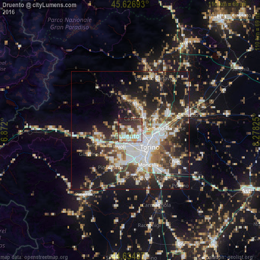
Analysis of Druento night lights 2016
Square area 10x10 km:
 18.03%
90-99
18.48%80-89
8.03%70-79
6.36%60-69
5.76%50-59
5.76%40-49
5.76%30-39
14.55%20-29
13.94%10-19
3.33%0-9
0%Square area 50x50 km:
8.4%90-99
8.38%80-89
3.14%70-79
3.49%60-69
3.86%50-59
5.01%40-49
5.57%30-39
6.14%20-29
10.45%10-19
20.52%0-9
25.04%Clear (daylight) street map image can be seen on geolist.org.
Map coordinates:
45° 37' 36.9" North, 6° 52' 19.2" East
45° 7' 59" North, 7° 34' 30.4" East
44° 38' 5.5" North, 8° 16' 41.7" East
Some cities around Druento sort by population:
• Collegno
6.1 km =3.8 mi,  185°
185°
• Rivoli
8.4 km =5.2 mi,  214°
214°
• Venaria Reale
4.5 km =2.8 mi,  100°
100°
• Grugliasco
7.6 km =4.7 mi,  177°
177°
• Alpignano
6 km =3.7 mi,  222°
222°
• Pianezza
3.8 km =2.4 mi, 211°
• Caselle Torinese
7 km =4.3 mi,  49°
49°
• Borgaro Torinese
6.6 km =4.1 mi,  72°
72°
3177471 (p: 8,232)
Sources (retrieved 2019-11-25):
» Earth at Night: Flat Maps 2012, 2016