Caselle Torinese night lights from space
Night Light of Caselle Torinese (Piedmont) from space (Italy) Src. Average luminocity for 10x10km area is 60.3682% and for 50x50km: 37.9743%.
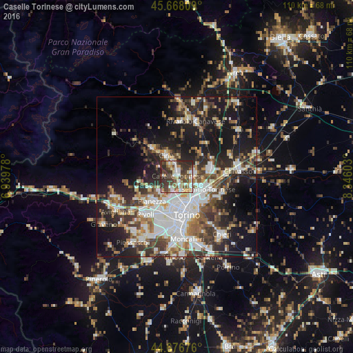
Analysis of Caselle Torinese night lights 2016
Square area 10x10 km:
 11.21%
90-99
14.09%80-89
6.97%70-79
7.42%60-69
6.06%50-59
8.03%40-49
13.48%30-39
19.09%20-29
13.64%10-19
0%0-9
0%Square area 50x50 km:
8.35%90-99
8.5%80-89
3.04%70-79
3.67%60-69
4%50-59
5.38%40-49
5.8%30-39
6.22%20-29
10.31%10-19
19.82%0-9
24.92%Clear (daylight) street map image can be seen on geolist.org.
Map coordinates:
45° 40' 5.1" North, 6° 56' 23.2" East
45° 10' 28.5" North, 7° 38' 34.4" East
44° 40' 36.3" North, 8° 20' 45.7" East
Some cities around Caselle Torinese sort by population:
• Venaria Reale
5.5 km =3.4 mi,  189°
189°
• Ciriè
7.5 km =4.7 mi,  334°
334°
• Leini
5.7 km =3.5 mi,  80°
80°
• Borgaro Torinese
2.8 km =1.7 mi,  159°
159°
• San Maurizio
4.8 km =3 mi,  348°
348°
• Druento
7 km =4.3 mi,  229°
229°
• Mappano
5.9 km =3.7 mi,  119°
119°
• Nole
9.4 km =5.8 mi,  322°
322°
3179911 (p: 11,817)
Sources (retrieved 2019-11-25):
» Earth at Night: Flat Maps 2012, 2016