Castello di Cisterna night lights from space
Night Light of Castello di Cisterna (Campania) from space (Italy) Src. Average luminocity for 10x10km area is 85.0289% and for 50x50km: 55.2237%.
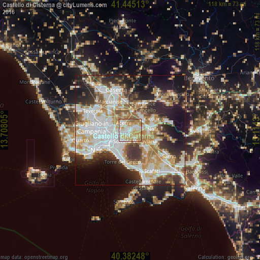
Analysis of Castello di Cisterna night lights 2016
Square area 10x10 km:
 21.09%
90-99
23.98%80-89
17.52%70-79
21.43%60-69
12.07%50-59
3.91%40-49
0%30-39
0%20-29
0%10-19
0%0-9
0%Square area 50x50 km:
14.41%90-99
13.77%80-89
5.7%70-79
7.44%60-69
8.07%50-59
5.33%40-49
4.39%30-39
7.24%20-29
10.21%10-19
12.39%0-9
11.06%Clear (daylight) street map image can be seen on geolist.org.
Map coordinates:
41° 26' 42.5" North, 13° 42' 29" East
40° 54' 57.4" North, 14° 24' 40.2" East
40° 22' 56.9" North, 15° 6' 51.5" East
Some cities around Castello di Cisterna sort by population:
• Acerra
4.6 km =2.9 mi,  313°
313°
• Pomigliano d'Arco
2.5 km =1.6 mi,  253°
253°
• Somma Vesuviana
5.3 km =3.3 mi,  154°
154°
• Marigliano
3.9 km =2.4 mi,  75°
75°
• Sant'Anastasia
5.3 km =3.3 mi,  188°
188°
• Brusciano
1.3 km =0.8 mi,  56°
56°
• Mariglianella
2.7 km =1.7 mi, 55°
• San Vitaliano
5.4 km =3.4 mi, 79°
6535296 (p: 7,187)
Sources (retrieved 2019-11-25):
» Earth at Night: Flat Maps 2012, 2016