San Vitaliano night lights from space
Night Light of San Vitaliano (Campania) from space (Italy) Src. Average luminocity for 10x10km area is 80.1429% and for 50x50km: 54.9235%.
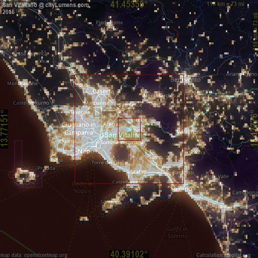
Analysis of San Vitaliano night lights 2016
Square area 10x10 km:
 14.8%
14.8%90-99
22.28%80-89
9.86%70-79
21.26%60-69
24.66%50-59
7.14%40-49
0%30-39
0%20-29
0%10-19
0%0-9
0%Square area 50x50 km:
13.74%90-99
13.3%80-89
5.68%70-79
6.94%60-69
8.29%50-59
5.69%40-49
5.22%30-39
7.83%20-29
10.99%10-19
13.16%0-9
9.16%Clear (daylight) street map image can be seen on geolist.org.
Map coordinates:
41° 27' 12.8" North, 13° 46' 17.4" East
40° 55' 27.9" North, 14° 28' 28.7" East
40° 23' 27.7" North, 15° 10' 39.9" East
Some cities around San Vitaliano sort by population:
• Marigliano
1.6 km =1 mi,  271°
271°
• Nola
4.5 km =2.8 mi,  87°
87°
• Brusciano
4.3 km =2.7 mi, 266°
• Saviano
3.3 km =2.1 mi,  130°
130°
• Castello di Cisterna
5.4 km =3.4 mi,  259°
259°
• Cimitile
4.7 km =2.9 mi,  65°
65°
• Mariglianella
3.2 km =2 mi,  280°
280°
• Camposano
5.6 km =3.5 mi,  56°
56°
6535297 (p: 6,072)
Sources (retrieved 2019-11-25):
» Earth at Night: Flat Maps 2012, 2016