Campobello di Licata night lights from space
Night Light of Campobello di Licata (Sicily) from space (Italy) Src. Average luminocity for 10x10km area is 16.6003% and for 50x50km: 10.271%.
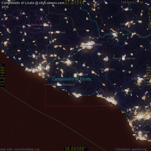
Analysis of Campobello di Licata night lights 2016
Square area 10x10 km:
 2.55%
2.55%90-99
0.85%80-89
3.74%70-79
1.53%60-69
1.7%50-59
2.55%40-49
0.85%30-39
3.91%20-29
1.19%10-19
7.65%0-9
73.47%Square area 50x50 km:
1.12%90-99
1.13%80-89
1.8%70-79
0.84%60-69
1.13%50-59
1.06%40-49
0.65%30-39
2.14%20-29
1.71%10-19
7.59%0-9
80.83%Clear (daylight) street map image can be seen on geolist.org.
Map coordinates:
37° 48' 54.5" North, 13° 12' 54" East
37° 15' 27.3" North, 13° 55' 5.2" East
36° 41' 45.2" North, 14° 37' 16.5" East
Some cities around Campobello di Licata sort by population:
• Licata
17.3 km =10.7 mi,  173°
173°
• Canicattì
12.8 km =8 mi,  331°
331°
• Palma di Montechiaro
15.4 km =9.6 mi,  241°
241°
• Ravanusa
4.6 km =2.9 mi,  77°
77°
• Riesi
14.8 km =9.2 mi, 79°
• Naro
11.7 km =7.3 mi,  289°
289°
• Sommatino
11.1 km =6.9 mi,  39°
39°
• Serradifalco
22.1 km =13.7 mi,  351°
351°
2525426 (p: 10,047)
Sources (retrieved 2019-11-25):
» Earth at Night: Flat Maps 2012, 2016