Camisano Vicentino night lights from space
Night Light of Camisano Vicentino (Veneto) from space (Italy) Src. Average luminocity for 10x10km area is 37.2636% and for 50x50km: 51.7671%.
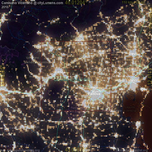
Analysis of Camisano Vicentino night lights 2016
Square area 10x10 km:
 4.09%
4.09%90-99
5.61%80-89
0%70-79
1.52%60-69
1.52%50-59
8.33%40-49
9.09%30-39
14.09%20-29
42.88%10-19
12.88%0-9
0%Square area 50x50 km:
7.47%90-99
9.88%80-89
4.97%70-79
6.72%60-69
7.98%50-59
11.86%40-49
11.51%30-39
11.35%20-29
13.39%10-19
9.77%0-9
5.1%Clear (daylight) street map image can be seen on geolist.org.
Map coordinates:
46° 0' 43.3" North, 11° 0' 18.2" East
45° 31' 17.6" North, 11° 42' 29.4" East
45° 1' 36.3" North, 12° 24' 40.7" East
Some cities around Camisano Vicentino sort by population:
• Vicenza
12.8 km =8 mi,  282°
282°
• Torri di Quartesolo
6.5 km =4 mi,  267°
267°
• Sarmeola
13.8 km =8.6 mi,  142°
142°
• Mestrino
9.8 km =6.1 mi,  155°
155°
• Monticello Conte Otto
13.6 km =8.5 mi,  308°
308°
• Carmignano di Brenta
11.6 km =7.2 mi,  359°
359°
• Fontaniva
13.1 km =8.1 mi,  15°
15°
• Limena
12.2 km =7.6 mi,  118°
118°
3181075 (p: 8,244)
Sources (retrieved 2019-11-25):
» Earth at Night: Flat Maps 2012, 2016