Zanè night lights from space
Night Light of Zanè (Veneto) from space (Italy) Src. Average luminocity for 10x10km area is 61.5712% and for 50x50km: 26.9395%.
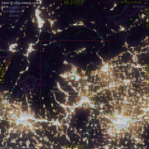
Analysis of Zanè night lights 2016
Square area 10x10 km:
 10.61%
90-99
17.42%80-89
3.79%70-79
6.52%60-69
7.88%50-59
16.06%40-49
11.21%30-39
11.06%20-29
13.64%10-19
1.82%0-9
0%Square area 50x50 km:
3.29%90-99
4.79%80-89
2.88%70-79
2.96%60-69
3.58%50-59
5.39%40-49
5.55%30-39
6.33%20-29
9.46%10-19
9.98%0-9
45.79%Clear (daylight) street map image can be seen on geolist.org.
Map coordinates:
46° 12' 38.6" North, 10° 44' 46.3" East
45° 43' 19.2" North, 11° 26' 57.6" East
45° 13' 44.3" North, 12° 9' 8.8" East
Some cities around Zanè sort by population:
• Schio
7.3 km =4.5 mi,  261°
261°
• Thiene
2.8 km =1.7 mi,  121°
121°
• Malo
7.5 km =4.7 mi,  200°
200°
• Dueville
12.5 km =7.8 mi,  140°
140°
• Marano Vicentino
3.2 km =2 mi, 204°
• Piovene Rocchette
4 km =2.5 mi,  341°
341°
• Breganze
8.9 km =5.5 mi,  102°
102°
• Santorso
4.9 km =3 mi,  285°
285°
3163916 (p: 6,600)
Sources (retrieved 2019-11-25):
» Earth at Night: Flat Maps 2012, 2016