Bientina night lights from space
Night Light of Bientina (Tuscany) from space (Italy) Src. Average luminocity for 10x10km area is 45.7682% and for 50x50km: 32.6031%.
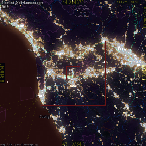
Analysis of Bientina night lights 2016
Square area 10x10 km:
 6.82%
6.82%90-99
8.94%80-89
3.33%70-79
5.76%60-69
6.52%50-59
5.15%40-49
10.91%30-39
11.21%20-29
15.45%10-19
25.76%0-9
0.15%Square area 50x50 km:
4.39%90-99
5.96%80-89
2.76%70-79
3.59%60-69
3.98%50-59
4.47%40-49
5.83%30-39
5.89%20-29
15.83%10-19
23.4%0-9
23.91%Clear (daylight) street map image can be seen on geolist.org.
Map coordinates:
44° 12' 51.7" North, 9° 55' 4.9" East
43° 42' 29.7" North, 10° 37' 16.2" East
43° 11' 52.2" North, 11° 19' 27.4" East
Some cities around Bientina sort by population:
• Cascina
6.4 km =4 mi,  235°
235°
• Pontedera
5.3 km =3.3 mi,  171°
171°
• Ponsacco
9.5 km =5.9 mi,  177°
177°
• Santa Croce sull'Arno
12.2 km =7.6 mi,  85°
85°
• Castelfranco di Sotto
10.1 km =6.3 mi, 92°
• Santa Maria a Monte
5.7 km =3.5 mi, 90°
• Fornacette
5.1 km =3.2 mi,  214°
214°
• Vicopisano
3.5 km =2.2 mi, 240°
3182040 (p: 5,121)
Sources (retrieved 2019-11-25):
» Earth at Night: Flat Maps 2012, 2016