Vengurla night lights from space
Night Light of Vengurla (Maharashtra) from space (India) Src. Average luminocity for 10x10km area is 3.2403% and for 50x50km: 4.0585%.
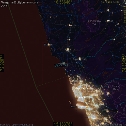
Analysis of Vengurla night lights 2016
Square area 10x10 km:
 0%
0%90-99
0%80-89
0%70-79
0%60-69
1.73%50-59
1.52%40-49
1.08%30-39
0.87%20-29
0.87%10-19
0%0-9
93.94%Square area 50x50 km:
0.08%90-99
0.37%80-89
0.45%70-79
0.33%60-69
0.62%50-59
1.09%40-49
1.31%30-39
1.25%20-29
1.4%10-19
2.02%0-9
91.08%Clear (daylight) street map image can be seen on geolist.org.
Map coordinates:
16° 32' 11.3" North, 72° 55' 43.3" East
15° 51' 40.5" North, 73° 37' 54.6" East
15° 11' 1.6" North, 74° 20' 5.8" East
Some cities around Vengurla sort by population:
• Sāvantvādi
20.9 km =13 mi,  76°
76°
• Mālvan
28.5 km =17.7 mi,  320°
320°
• Vagator
31.7 km =19.7 mi,  157°
157°
• Kudāl
17.8 km =11.1 mi,  19°
19°
• Solim
31 km =19.3 mi,  152°
152°
• Arambol
20.9 km =13 mi, 158°
• Colovale
32.5 km =20.2 mi,  140°
140°
• Pernem
23.3 km =14.5 mi,  131°
131°
1253257 (p: 12,498)
Sources (retrieved 2019-11-25):
» Earth at Night: Flat Maps 2012, 2016