Vāsudevanallūr night lights from space
Night Light of Vāsudevanallūr (Tamil Nadu) from space (India) Src. Average luminocity for 10x10km area is 4.2208% and for 50x50km: 4.3067%.
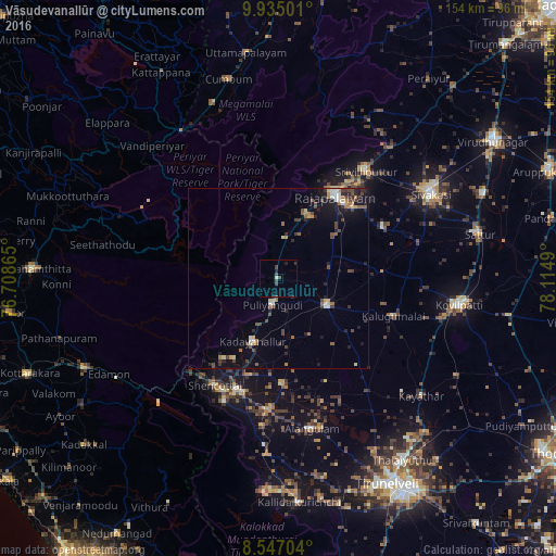
Analysis of Vāsudevanallūr night lights 2016
Square area 10x10 km:
 0%
0%90-99
0.87%80-89
0%70-79
0%60-69
0%50-59
0%40-49
3.68%30-39
1.08%20-29
1.08%10-19
0.65%0-9
92.64%Square area 50x50 km:
0.29%90-99
0.5%80-89
0.37%70-79
0.36%60-69
0.65%50-59
0.63%40-49
1.27%30-39
0.65%20-29
1.22%10-19
2.48%0-9
91.59%Clear (daylight) street map image can be seen on geolist.org.
Map coordinates:
9° 56' 6" North, 76° 42' 31.1" East
9° 14' 30.2" North, 77° 24' 42.4" East
8° 32' 49.3" North, 78° 6' 53.6" East
Some cities around Vāsudevanallūr sort by population:
• Rajapalaiyam
28.2 km =17.5 mi,  33°
33°
• Kadayanallur
20.3 km =12.6 mi,  202°
202°
• Thenkasi
33.1 km =20.6 mi, 198°
• Puliyangudi
7.6 km =4.7 mi,  191°
191°
• Sūrandai
29.6 km =18.4 mi,  178°
178°
• Sivagiri
11.6 km =7.2 mi,  9°
9°
• Kalugumalai
33.9 km =21.1 mi,  107°
107°
• Cholapuram
21.1 km =13.1 mi,  54°
54°
1253357 (p: 19,021)
Sources (retrieved 2019-11-25):
» Earth at Night: Flat Maps 2012, 2016