Kalugumalai night lights from space
Night Light of Kalugumalai (Tamil Nadu) from space (India) Src. Average luminocity for 10x10km area is 5.0996% and for 50x50km: 4.0229%.
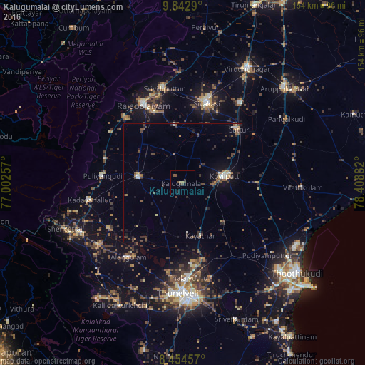
Analysis of Kalugumalai night lights 2016
Square area 10x10 km:
 0%
0%90-99
0.65%80-89
0.22%70-79
0%60-69
0.87%50-59
2.6%40-49
1.73%30-39
1.73%20-29
0.65%10-19
1.08%0-9
90.48%Square area 50x50 km:
0.13%90-99
0.54%80-89
0.32%70-79
0.38%60-69
0.38%50-59
0.71%40-49
1.18%30-39
1.12%20-29
1.15%10-19
1.95%0-9
92.14%Clear (daylight) street map image can be seen on geolist.org.
Map coordinates:
9° 50' 34.4" North, 77° 0' 9.3" East
9° 8' 57.9" North, 77° 42' 20.5" East
8° 27' 16.5" North, 78° 24' 31.8" East
Some cities around Kalugumalai sort by population:
• Kovilpatti
18.2 km =11.3 mi,  82°
82°
• Puliyangudi
33.9 km =21.1 mi,  274°
274°
• Sattur
33.2 km =20.6 mi,  46°
46°
• Ettaiyapuram
31.3 km =19.4 mi,  91°
91°
• Gangaikondān
33.4 km =20.8 mi,  165°
165°
• Kayattār
23.6 km =14.7 mi,  161°
161°
• Cholapuram
27.1 km =16.8 mi,  326°
326°
• Elāyirampannai
18.8 km =11.7 mi,  44°
44°
1268310 (p: 15,423)
Sources (retrieved 2019-11-25):
» Earth at Night: Flat Maps 2012, 2016