Tīrthahalli night lights from space
Night Light of Tīrthahalli (Karnataka) from space (India) Src. Average luminocity for 10x10km area is 6.3037% and for 50x50km: 0.367%.
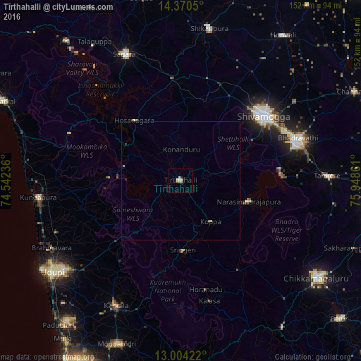
Analysis of Tīrthahalli night lights 2016
Square area 10x10 km:
 1.03%
1.03%90-99
1.03%80-89
1.24%70-79
2.27%60-69
0.21%50-59
0%40-49
0%30-39
0%20-29
0.83%10-19
1.65%0-9
91.74%Square area 50x50 km:
0.04%90-99
0.04%80-89
0.05%70-79
0.16%60-69
0.04%50-59
0%40-49
0%30-39
0.02%20-29
0.08%10-19
0.07%0-9
99.5%Clear (daylight) street map image can be seen on geolist.org.
Map coordinates:
14° 22' 13.8" North, 74° 32' 32.5" East
13° 41' 18.1" North, 75° 14' 43.7" East
13° 0' 15.2" North, 75° 56' 55" East
Some cities around Tīrthahalli sort by population:
• Shimoga
44.1 km =27.4 mi,  52°
52°
• Bhadrāvati
52.7 km =32.7 mi,  70°
70°
• Someshwar
29.2 km =18.1 mi,  221°
221°
• Narasimharājapura
30.1 km =18.7 mi,  106°
106°
• Beltangadi
33.3 km =20.7 mi,  10°
10°
• Kumsi
44 km =27.3 mi,  22°
22°
• Hosanagara
31.8 km =19.8 mi,  322°
322°
• Koppa
21.7 km =13.5 mi,  144°
144°
1254396 (p: 15,422)
Sources (retrieved 2019-11-25):
» Earth at Night: Flat Maps 2012, 2016