Takhatpur night lights from space
Night Light of Takhatpur (Chhattisgarh) from space (India) Src. Average luminocity for 10x10km area is 49.7262% and for 50x50km: 37.9806%.
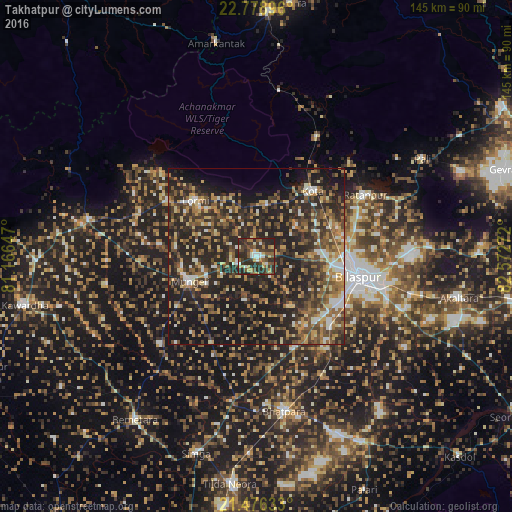
Analysis of Takhatpur night lights 2016
Square area 10x10 km:
 5.95%
5.95%90-99
6.94%80-89
3.97%70-79
7.54%60-69
6.35%50-59
10.91%40-49
11.11%30-39
16.27%20-29
30.56%10-19
0.4%0-9
0%Square area 50x50 km:
2.59%90-99
4.39%80-89
4.01%70-79
5.2%60-69
6.22%50-59
8%40-49
8.72%30-39
8.79%20-29
20.94%10-19
23.2%0-9
7.94%Clear (daylight) street map image can be seen on geolist.org.
Map coordinates:
22° 46' 44.3" North, 81° 9' 59.3" East
22° 7' 44.9" North, 81° 52' 10.5" East
21° 28' 34.8" North, 82° 34' 21.8" East
Some cities around Takhatpur sort by population:
• Bilāspur
29.9 km =18.6 mi,  100°
100°
• Bhātāpāra
44.5 km =27.7 mi,  169°
169°
• Mungeli
20.2 km =12.6 mi,  249°
249°
• Ratanpur
35.4 km =22 mi,  60°
60°
• Kotā
24.3 km =15.1 mi,  40°
40°
• Pandaria
48.5 km =30.1 mi,  282°
282°
• Lormi
23.6 km =14.7 mi,  313°
313°
• Pāndātarai
56.1 km =34.9 mi, 276°
1255212 (p: 17,859)
Sources (retrieved 2019-11-25):
» Earth at Night: Flat Maps 2012, 2016