Sadābād night lights from space
Night Light of Sadābād (Uttar Pradesh) from space (India) Src. Average luminocity for 10x10km area is 16.8201% and for 50x50km: 19.239%.
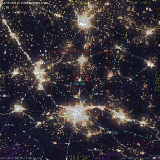

Analysis of Sadābād night lights 2016
Square area 10x10 km:
 0.57%
0.57%90-99
0.19%80-89
0.19%70-79
2.08%60-69
0.76%50-59
3.6%40-49
5.49%30-39
6.82%20-29
7.39%10-19
17.42%0-9
55.49%Square area 50x50 km:
1.16%90-99
1.9%80-89
2.09%70-79
1.18%60-69
2.26%50-59
3.4%40-49
4.45%30-39
6.37%20-29
8.08%10-19
17.23%0-9
51.88%Clear (daylight) street map image can be seen on geolist.org.
Map coordinates:
28° 3' 37.6" North, 77° 20' 4.1" East
27° 26' 17.4" North, 78° 2' 15.3" East
26° 48' 44.6" North, 78° 44' 26.6" East
Some cities around Sadābād sort by population:
• Agra
28.4 km =17.6 mi,  184°
184°
• Hāthras
17.6 km =10.9 mi,  4°
4°
• Jalesar
26.5 km =16.5 mi,  81°
81°
• Itimādpur
27.6 km =17.1 mi,  144°
144°
• Rāya
27.7 km =17.2 mi,  298°
298°
• Mursān
18.2 km =11.3 mi,  328°
328°
• Baldev
21.5 km =13.4 mi,  260°
260°
• Beswān
27.1 km =16.8 mi, 325°
1257896 (p: 36,093)
Sources (retrieved 2019-11-25):
» Earth at Night: Flat Maps 2012, 2016