Rājgurunagar night lights from space
Night Light of Rājgurunagar (Maharashtra) from space (India) Src. Average luminocity for 10x10km area is 23.5498% and for 50x50km: 28.1451%.
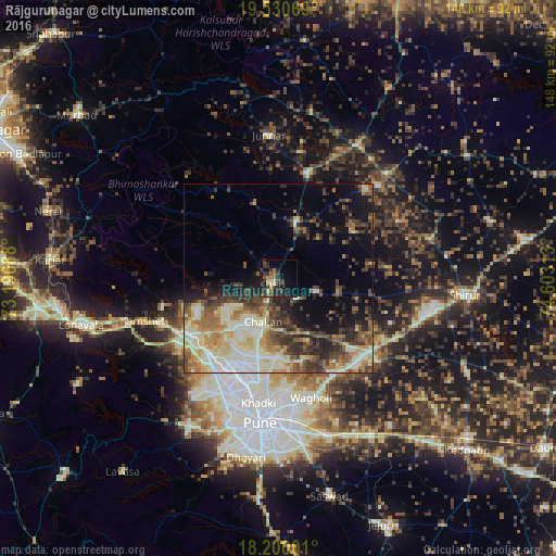
Analysis of Rājgurunagar night lights 2016
Square area 10x10 km:
 0%
0%90-99
1.95%80-89
3.25%70-79
1.08%60-69
6.28%50-59
3.46%40-49
4.11%30-39
9.09%20-29
10.82%10-19
19.26%0-9
40.69%Square area 50x50 km:
2.62%90-99
8.28%80-89
3.5%70-79
3.44%60-69
3.32%50-59
4.37%40-49
4.46%30-39
5.41%20-29
5.92%10-19
8.48%0-9
50.2%Clear (daylight) street map image can be seen on geolist.org.
Map coordinates:
19° 31' 50.5" North, 73° 11' 48.8" East
18° 52' 0" North, 73° 54' 0" East
18° 12' 0" North, 74° 36' 11.3" East
Some cities around Rājgurunagar sort by population:
• Pimpri
28.8 km =17.9 mi,  199°
199°
• Talegaon Dābhāde
27.8 km =17.3 mi,  238°
238°
• Kalamb
20.6 km =12.8 mi,  16°
16°
• Koregaon
29.7 km =18.5 mi,  145°
145°
• Chākan
12.4 km =7.7 mi, 198°
• Alandi
21 km =13 mi,  180°
180°
• Manchar
16 km =9.9 mi, 16°
• Dehu
21.7 km =13.5 mi,  220°
220°
1258859 (p: 18,846)
Sources (retrieved 2019-11-25):
» Earth at Night: Flat Maps 2012, 2016