Manchar night lights from space
Night Light of Manchar (Maharashtra) from space (India) Src. Average luminocity for 10x10km area is 18.3506% and for 50x50km: 14.9033%.
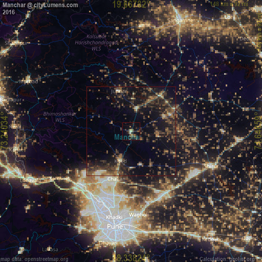
Analysis of Manchar night lights 2016
Square area 10x10 km:
 0%
0%90-99
1.52%80-89
2.16%70-79
0.87%60-69
3.25%50-59
3.25%40-49
3.9%30-39
7.58%20-29
8.23%10-19
7.79%0-9
61.47%Square area 50x50 km:
0.08%90-99
1.2%80-89
0.97%70-79
0.84%60-69
1.71%50-59
3.43%40-49
4.64%30-39
5.8%20-29
7.03%10-19
13.36%0-9
60.94%Clear (daylight) street map image can be seen on geolist.org.
Map coordinates:
19° 40' 4.2" North, 73° 14' 25.2" East
19° 0' 15.7" North, 73° 56' 36.5" East
18° 20' 17.7" North, 74° 38' 47.7" East
Some cities around Manchar sort by population:
• Talegaon Dābhāde
41.1 km =25.5 mi,  223°
223°
• Kalamb
4.6 km =2.9 mi,  15°
15°
• Junnar
23.8 km =14.8 mi,  342°
342°
• Koregaon
41.7 km =25.9 mi,  163°
163°
• Chākan
28.4 km =17.6 mi,  197°
197°
• Alandi
36.6 km =22.7 mi,  187°
187°
• Rājgurunagar
16 km =9.9 mi, 196°
• Dehu
36.8 km =22.9 mi,  210°
210°
1263937 (p: 14,740)
Sources (retrieved 2019-11-25):
» Earth at Night: Flat Maps 2012, 2016