Rabūpura night lights from space
Night Light of Rabūpura (Uttar Pradesh) from space (India) Src. Average luminocity for 10x10km area is 29.5754% and for 50x50km: 41.1912%.
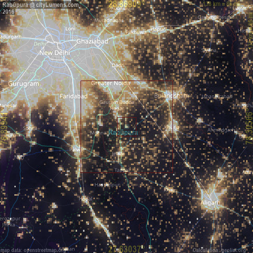
Analysis of Rabūpura night lights 2016
Square area 10x10 km:
 0.6%
0.6%90-99
3.17%80-89
4.17%70-79
2.38%60-69
4.96%50-59
3.57%40-49
5.95%30-39
7.94%20-29
13.89%10-19
44.25%0-9
9.13%Square area 50x50 km:
3.13%90-99
5.48%80-89
6.13%70-79
5.81%60-69
7.02%50-59
7.4%40-49
9.49%30-39
10.17%20-29
12.77%10-19
24.35%0-9
8.27%Clear (daylight) street map image can be seen on geolist.org.
Map coordinates:
28° 52' 8.7" North, 76° 53' 57.9" East
28° 15' 5.5" North, 77° 36' 9.1" East
27° 37' 49.3" North, 78° 18' 20.4" East
Some cities around Rabūpura sort by population:
• Greater Noida
28 km =17.4 mi,  346°
346°
• Palwal
29.6 km =18.4 mi,  246°
246°
• Khurja
24.8 km =15.4 mi,  89°
89°
• Sikandarābād
24.3 km =15.1 mi,  23°
23°
• Jewar
15.1 km =9.4 mi,  197°
197°
• Dankaur
12 km =7.5 mi,  337°
337°
• Jahāngīrpur
12.9 km =8 mi,  128°
128°
• Bīlāspur
15.7 km =9.8 mi,  7°
7°
1259082 (p: 13,949)
Sources (retrieved 2019-11-25):
» Earth at Night: Flat Maps 2012, 2016