Bīlāspur night lights from space
Night Light of Bīlāspur (Uttar Pradesh) from space (India) Src. Average luminocity for 10x10km area is 68.3591% and for 50x50km: 51.6201%.
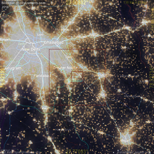
Analysis of Bīlāspur night lights 2016
Square area 10x10 km:
 5.36%
5.36%90-99
14.68%80-89
11.9%70-79
16.27%60-69
21.03%50-59
10.71%40-49
9.13%30-39
6.15%20-29
4.17%10-19
0.6%0-9
0%Square area 50x50 km:
7.15%90-99
10.42%80-89
9.31%70-79
6.41%60-69
7.75%50-59
7.36%40-49
8.98%30-39
8.76%20-29
12.04%10-19
19.65%0-9
2.16%Clear (daylight) street map image can be seen on geolist.org.
Map coordinates:
29° 0' 28.9" North, 76° 55' 15.9" East
28° 23' 28.6" North, 77° 37' 27.2" East
27° 46' 15.3" North, 78° 19' 38.4" East
Some cities around Bīlāspur sort by population:
• Greater Noida
14.5 km =9 mi,  323°
323°
• Bulandshahr
22.9 km =14.2 mi,  86°
86°
• Khurja
27.3 km =17 mi,  124°
124°
• Sikandarābād
10 km =6.2 mi,  47°
47°
• Dādri
19.2 km =11.9 mi,  339°
339°
• Rabūpura
15.7 km =9.8 mi,  187°
187°
• Dankaur
8.1 km =5 mi,  236°
236°
• Jahāngīrpur
24.9 km =15.5 mi,  161°
161°
1275635 (p: 8,036)
Sources (retrieved 2019-11-25):
» Earth at Night: Flat Maps 2012, 2016