Padampur night lights from space
Night Light of Padampur (Rajasthan) from space (India) Src. Average luminocity for 10x10km area is 1% and for 50x50km: 1.3639%.
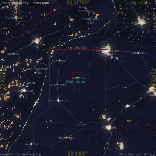
Analysis of Padampur night lights 2016
Square area 10x10 km:
 0%
0%90-99
0%80-89
0%70-79
0.79%60-69
0%50-59
0.4%40-49
0.4%30-39
0%20-29
0%10-19
0%0-9
98.41%Square area 50x50 km:
0.32%90-99
0.42%80-89
0.1%70-79
0.09%60-69
0.04%50-59
0.02%40-49
0.2%30-39
0.11%20-29
0.19%10-19
0.75%0-9
97.76%Clear (daylight) street map image can be seen on geolist.org.
Map coordinates:
30° 19' 3.7" North, 72° 55' 20.2" East
29° 42' 31.9" North, 73° 37' 31.4" East
29° 5' 46.7" North, 74° 19' 42.7" East
Some cities around Padampur sort by population:
• Gangānagar
33.6 km =20.9 mi,  45°
45°
• Bahawalnagar, PK
48.2 km =30 mi,  311°
311°
• Harunabad, PK
48.3 km =30 mi,  257°
257°
• Sūratgarh
50.6 km =31.4 mi,  148°
148°
• Rāisinghnagar
25.7 km =16 mi,  221°
221°
• Dunga Bunga, PK
37.2 km =23.1 mi,  277°
277°
• Karanpur
22 km =13.7 mi, 311°
• Dinan Bashnoian Wala, PK
35.3 km =21.9 mi, 280°
1260938 (p: 18,454)
Sources (retrieved 2019-11-25):
» Earth at Night: Flat Maps 2012, 2016