North Guwāhāti night lights from space
Night Light of North Guwāhāti (Assam) from space (India) Src. Average luminocity for 10x10km area is 76.6627% and for 50x50km: 20.5911%.
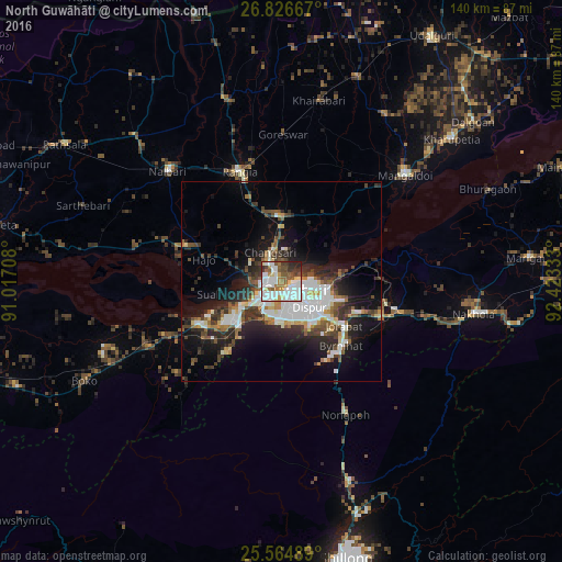
Analysis of North Guwāhāti night lights 2016
Square area 10x10 km:
 22.82%
90-99
27.78%80-89
7.54%70-79
3.17%60-69
9.33%50-59
10.12%40-49
5.75%30-39
6.35%20-29
6.55%10-19
0.6%0-9
0%Square area 50x50 km:
3.64%90-99
5.48%80-89
1.46%70-79
1.46%60-69
1.86%50-59
2.59%40-49
3.2%30-39
3.5%20-29
6.37%10-19
10.62%0-9
59.82%Clear (daylight) street map image can be seen on geolist.org.
Map coordinates:
26° 49' 36" North, 91° 1' 1.5" East
26° 11' 51" North, 91° 43' 12.7" East
25° 33' 53.6" North, 92° 25' 24" East
Some cities around North Guwāhāti sort by population:
• Guwahati
2.9 km =1.8 mi,  119°
119°
• Rangia
29.9 km =18.6 mi,  339°
339°
• Mangaldai
41.2 km =25.6 mi,  48°
48°
• Khārupatia
55.5 km =34.5 mi, 50°
• Hājo
20.2 km =12.6 mi,  285°
285°
• Nongpoh
36.4 km =22.6 mi,  154°
154°
• Soalkuchi
15.2 km =9.4 mi,  257°
257°
• Dispur
10.6 km =6.6 mi,  130°
130°
1261186 (p: 17,516)
Sources (retrieved 2019-11-25):
» Earth at Night: Flat Maps 2012, 2016