Murgūd night lights from space
Night Light of Murgūd (Maharashtra) from space (India) Src. Average luminocity for 10x10km area is 1.9194% and for 50x50km: 6.0924%.
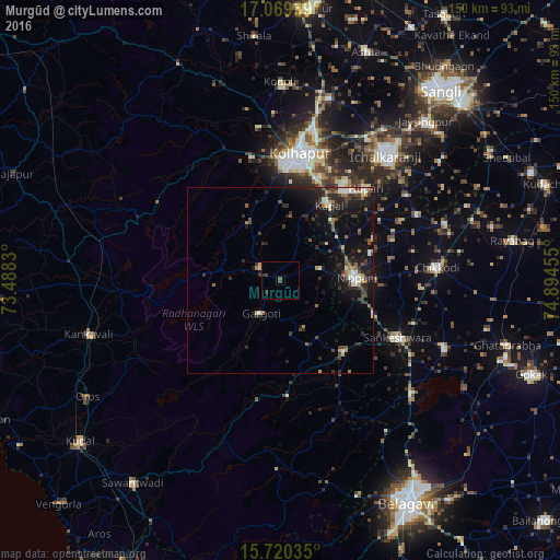
Analysis of Murgūd night lights 2016
Square area 10x10 km:
 0%
0%90-99
0%80-89
0%70-79
0%60-69
0%50-59
0.83%40-49
1.03%30-39
1.03%20-29
1.24%10-19
0%0-9
95.87%Square area 50x50 km:
0.42%90-99
0.94%80-89
0.36%70-79
0.53%60-69
0.73%50-59
0.79%40-49
1.19%30-39
1.44%20-29
2.52%10-19
5.56%0-9
85.51%Clear (daylight) street map image can be seen on geolist.org.
Map coordinates:
17° 4' 9.8" North, 73° 29' 17.9" East
16° 23' 45.7" North, 74° 11' 29.1" East
15° 43' 13.3" North, 74° 53' 40.4" East
Some cities around Murgūd sort by population:
• Kolhāpur
33.6 km =20.9 mi,  7°
7°
• Nipāni
20.4 km =12.7 mi,  89°
89°
• Chikodi
42.2 km =26.2 mi, 85°
• Sankeshwar
34.7 km =21.6 mi,  116°
116°
• Gadhinglaj
25.6 km =15.9 mi,  138°
138°
• Kāgal
24.1 km =15 mi,  33°
33°
• Sadalgi
40.6 km =25.2 mi,  63°
63°
• Ajra
31.2 km =19.4 mi,  176°
176°
1262435 (p: 9,395)
Sources (retrieved 2019-11-25):
» Earth at Night: Flat Maps 2012, 2016