Mungaoli night lights from space
Night Light of Mungaoli (Madhya Pradesh) from space (India) Src. Average luminocity for 10x10km area is 12.5218% and for 50x50km: 8.7233%.
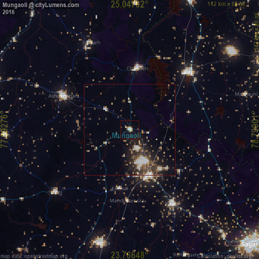

Analysis of Mungaoli night lights 2016
Square area 10x10 km:
 0.99%
0.99%90-99
1.59%80-89
1.39%70-79
2.38%60-69
0.6%50-59
0.99%40-49
2.38%30-39
1.79%20-29
1.79%10-19
4.56%0-9
81.55%Square area 50x50 km:
0.96%90-99
1.28%80-89
0.71%70-79
0.41%60-69
1.05%50-59
1.58%40-49
2.08%30-39
2.44%20-29
2.95%10-19
5.08%0-9
81.45%Clear (daylight) street map image can be seen on geolist.org.
Map coordinates:
25° 2' 49.3" North, 77° 23' 33.9" East
24° 24' 30.1" North, 78° 5' 45.2" East
23° 45' 59.3" North, 78° 47' 56.4" East
Some cities around Mungaoli sort by population:
• Lalitpur
45.3 km =28.1 mi,  46°
46°
• Ashoknagar
41.3 km =25.7 mi,  296°
296°
• Etāwa
27.3 km =17 mi,  156°
156°
• Chanderi
34.2 km =21.3 mi,  7°
7°
• Khurai
47 km =29.2 mi,  149°
149°
• Korwai
32.8 km =20.4 mi,  189°
189°
• Pāli
33.7 km =20.9 mi,  74°
74°
• Bamora
39.3 km =24.4 mi,  180°
180°
1262485 (p: 20,081)
Sources (retrieved 2019-11-25):
» Earth at Night: Flat Maps 2012, 2016