Manāli night lights from space
Night Light of Manāli (Himachal Pradesh) from space (India) Src. Average luminocity for 10x10km area is 11.3626% and for 50x50km: 0.755%.
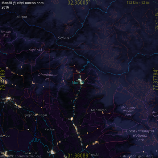
Analysis of Manāli night lights 2016
Square area 10x10 km:
 1.28%
1.28%90-99
2.75%80-89
1.83%70-79
0%60-69
0.73%50-59
1.83%40-49
1.83%30-39
2.2%20-29
1.47%10-19
0.73%0-9
85.35%Square area 50x50 km:
0.05%90-99
0.11%80-89
0.07%70-79
0.03%60-69
0.06%50-59
0.12%40-49
0.26%30-39
0.23%20-29
0.2%10-19
0.07%0-9
98.8%Clear (daylight) street map image can be seen on geolist.org.
Map coordinates:
32° 51' 0.2" North, 76° 28' 18.1" East
32° 15' 26.6" North, 77° 10' 29.3" East
31° 39' 39.1" North, 77° 52' 40.6" East
Some cities around Manāli sort by population:
• Mandi
64.8 km =40.3 mi,  200°
200°
• Sundarnagar
84.2 km =52.3 mi, 197°
• Kulu
33.8 km =21 mi,  190°
190°
• Dharamsala
80.5 km =50 mi,  267°
267°
• Kyelang
37.7 km =23.4 mi,  338°
338°
• Kāngar
87.8 km =54.6 mi,  257°
257°
• Tīra Sujānpur
78.7 km =48.9 mi,  233°
233°
• Jogindarnagar
47.1 km =29.3 mi, 230°
1263967 (p: 8,341)
Sources (retrieved 2019-11-25):
» Earth at Night: Flat Maps 2012, 2016