Mahāban night lights from space
Night Light of Mahāban (Uttar Pradesh) from space (India) Src. Average luminocity for 10x10km area is 41.7936% and for 50x50km: 21.9874%.
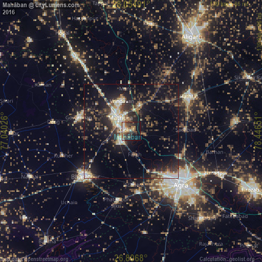
Analysis of Mahāban night lights 2016
Square area 10x10 km:
 5.11%
5.11%90-99
5.87%80-89
4.73%70-79
4.92%60-69
7.01%50-59
9.28%40-49
6.82%30-39
9.47%20-29
14.02%10-19
24.43%0-9
8.33%Square area 50x50 km:
1.88%90-99
2.96%80-89
3.2%70-79
1.4%60-69
2.19%50-59
3.41%40-49
4.11%30-39
5.77%20-29
8.83%10-19
19.43%0-9
46.84%Clear (daylight) street map image can be seen on geolist.org.
Map coordinates:
28° 3' 17.7" North, 77° 2' 24.9" East
27° 25' 57.4" North, 77° 44' 36.2" East
26° 48' 24.5" North, 78° 26' 47.4" East
Some cities around Mahāban sort by population:
• Mathura
10.6 km =6.6 mi,  318°
318°
• Vrindāvan
17.1 km =10.6 mi,  344°
344°
• Rāya
14.5 km =9 mi,  18°
18°
• Mursān
25.3 km =15.7 mi,  50°
50°
• Baldev
8.3 km =5.2 mi,  110°
110°
• Farah
12.6 km =7.8 mi,  171°
171°
• Rādhākund
26.9 km =16.7 mi,  292°
292°
• Beswān
26.5 km =16.5 mi,  30°
30°
1264490 (p: 9,514)
Sources (retrieved 2019-11-25):
» Earth at Night: Flat Maps 2012, 2016