Maghar night lights from space
Night Light of Maghar (Uttar Pradesh) from space (India) Src. Average luminocity for 10x10km area is 38.4147% and for 50x50km: 24.3262%.
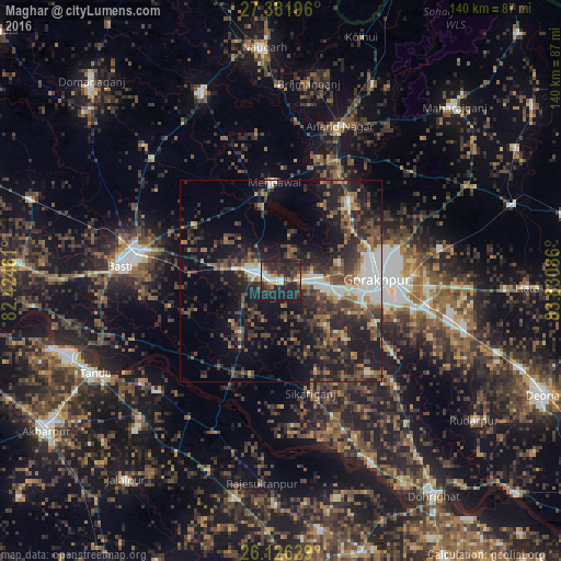
Analysis of Maghar night lights 2016
Square area 10x10 km:
 4.56%
4.56%90-99
5.75%80-89
3.77%70-79
3.57%60-69
3.37%50-59
3.37%40-49
7.34%30-39
12.3%20-29
29.37%10-19
26.59%0-9
0%Square area 50x50 km:
3.16%90-99
2.88%80-89
1.5%70-79
1.46%60-69
3.35%50-59
4.45%40-49
5.68%30-39
6.84%20-29
11.05%10-19
17.99%0-9
41.62%Clear (daylight) street map image can be seen on geolist.org.
Map coordinates:
27° 22' 55.1" North, 82° 25' 28.6" East
26° 45' 21.1" North, 83° 7' 39.8" East
26° 7' 34.6" North, 83° 49' 51.1" East
Some cities around Maghar sort by population:
• Gorakhpur
24 km =14.9 mi,  87°
87°
• Bastī
41 km =25.5 mi,  275°
275°
• Khalīlābād
5.9 km =3.7 mi,  288°
288°
• Mehndāwal
24.5 km =15.2 mi,  355°
355°
• Pipraich
40.4 km =25.1 mi,  78°
78°
• Bānsgāon
31.4 km =19.5 mi,  136°
136°
• Atraulia
50.3 km =31.3 mi,  200°
200°
• Anandnagar
40.9 km =25.4 mi,  20°
20°
1264504 (p: 17,011)
Sources (retrieved 2019-11-25):
» Earth at Night: Flat Maps 2012, 2016