Manjhanpur night lights from space
Night Light of Manjhanpur (Uttar Pradesh) from space (India) Src. Average luminocity for 10x10km area is 27.7599% and for 50x50km: 17.508%.
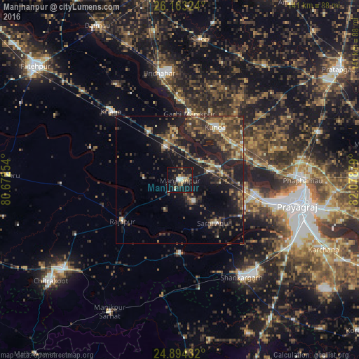
Analysis of Manjhanpur night lights 2016
Square area 10x10 km:
 2.58%
2.58%90-99
3.97%80-89
2.98%70-79
2.98%60-69
1.39%50-59
4.17%40-49
4.76%30-39
4.76%20-29
9.52%10-19
45.04%0-9
17.86%Square area 50x50 km:
0.68%90-99
1.41%80-89
1.45%70-79
2.22%60-69
2.3%50-59
3.84%40-49
5.09%30-39
5.19%20-29
6.43%10-19
16.61%0-9
54.78%Clear (daylight) street map image can be seen on geolist.org.
Map coordinates:
26° 9' 47.7" North, 80° 40' 21.1" East
25° 31' 49.7" North, 81° 22' 32.4" East
24° 53' 39.6" North, 82° 4' 43.6" East
Some cities around Manjhanpur sort by population:
• Kunda
25 km =15.5 mi,  33°
33°
• Sarāi Ākil
21.6 km =13.4 mi,  141°
141°
• Bharwāri
12.1 km =7.5 mi,  73°
73°
• Karārī
10.1 km =6.3 mi,  149°
149°
• Rājāpur
27.6 km =17.1 mi,  234°
234°
• Sirāthu
13.8 km =8.6 mi,  335°
335°
• Chail
28.2 km =17.5 mi,  114°
114°
• Kishanpur
37.5 km =23.3 mi,  289°
289°
1263691 (p: 16,939)
Sources (retrieved 2019-11-25):
» Earth at Night: Flat Maps 2012, 2016