Bharwāri night lights from space
Night Light of Bharwāri (Uttar Pradesh) from space (India) Src. Average luminocity for 10x10km area is 37.2784% and for 50x50km: 27.9167%.
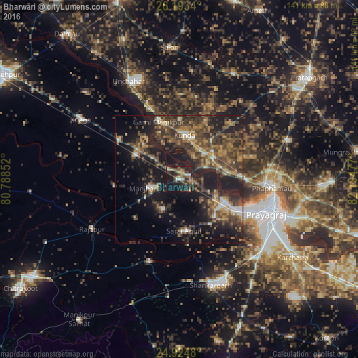
Analysis of Bharwāri night lights 2016
Square area 10x10 km:
 2.84%
2.84%90-99
3.79%80-89
6.63%70-79
3.41%60-69
4.36%50-59
7.58%40-49
8.9%30-39
7.01%20-29
19.32%10-19
29.73%0-9
6.44%Square area 50x50 km:
1.33%90-99
2.62%80-89
2.28%70-79
3.84%60-69
4.05%50-59
6.2%40-49
8.41%30-39
8.75%20-29
10.09%10-19
22.16%0-9
30.25%Clear (daylight) street map image can be seen on geolist.org.
Map coordinates:
26° 11' 36.2" North, 80° 47' 18.7" East
25° 33' 38.8" North, 81° 29' 29.9" East
24° 55' 29.3" North, 82° 11' 41.2" East
Some cities around Bharwāri sort by population:
• Allahābād
37.6 km =23.4 mi,  110°
110°
• Kunda
17.5 km =10.9 mi,  7°
7°
• Sarāi Ākil
20.3 km =12.6 mi,  174°
174°
• Manjhanpur
12.1 km =7.5 mi,  253°
253°
• Karārī
13.7 km =8.5 mi,  208°
208°
• Rājāpur
39.2 km =24.4 mi,  240°
240°
• Sirāthu
19.6 km =12.2 mi,  297°
297°
• Chail
20.5 km =12.7 mi,  136°
136°
1276095 (p: 16,411)
Sources (retrieved 2019-11-25):
» Earth at Night: Flat Maps 2012, 2016