Koradāchcheri night lights from space
Night Light of Koradāchcheri (Tamil Nadu) from space (India) Src. Average luminocity for 10x10km area is 14.7025% and for 50x50km: 9.154%.
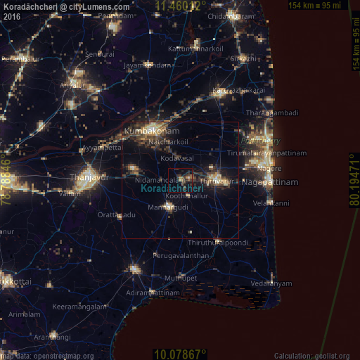
Analysis of Koradāchcheri night lights 2016
Square area 10x10 km:
 0.62%
0.62%90-99
0.21%80-89
0%70-79
1.03%60-69
3.93%50-59
2.48%40-49
3.72%30-39
6.4%20-29
6.2%10-19
8.06%0-9
67.36%Square area 50x50 km:
0.22%90-99
0.91%80-89
0.92%70-79
1.29%60-69
0.72%50-59
1.19%40-49
2.79%30-39
3.12%20-29
3.8%10-19
5.92%0-9
79.14%Clear (daylight) street map image can be seen on geolist.org.
Map coordinates:
11° 27' 36.4" North, 78° 47' 18.5" East
10° 46' 12.7" North, 79° 29' 29.7" East
10° 4' 43.2" North, 80° 11' 41" East
Some cities around Koradāchcheri sort by population:
• Kumbakonam
24 km =14.9 mi,  332°
332°
• Mannargudi
12.4 km =7.7 mi,  201°
201°
• Thiruvarur
15.9 km =9.9 mi,  88°
88°
• Koothanallur
6.2 km =3.9 mi,  154°
154°
• Ammāpettai
19 km =11.8 mi,  278°
278°
• Valangaiman
17.1 km =10.6 mi,  321°
321°
• Nannilam
17.8 km =11.1 mi,  46°
46°
• Needamangalam
8 km =5 mi,  272°
272°
1266144 (p: 6,151)
Sources (retrieved 2019-11-25):
» Earth at Night: Flat Maps 2012, 2016