Koothanallur night lights from space
Night Light of Koothanallur (Tamil Nadu) from space (India) Src. Average luminocity for 10x10km area is 9.4711% and for 50x50km: 6.9779%.
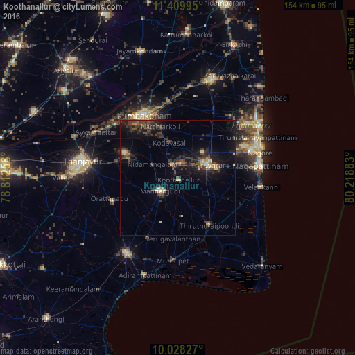

Analysis of Koothanallur night lights 2016
Square area 10x10 km:
 0%
0%90-99
0%80-89
1.65%70-79
0%60-69
0%50-59
1.45%40-49
3.93%30-39
2.27%20-29
1.45%10-19
8.68%0-9
80.58%Square area 50x50 km:
0.07%90-99
0.69%80-89
0.53%70-79
0.7%60-69
0.51%50-59
0.94%40-49
2.23%30-39
2.31%20-29
3.12%10-19
5.47%0-9
83.42%Clear (daylight) street map image can be seen on geolist.org.
Map coordinates:
11° 24' 35.8" North, 78° 48' 45.3" East
10° 43' 11.6" North, 79° 30' 56.5" East
10° 1' 41.8" North, 80° 13' 7.8" East
Some cities around Koothanallur sort by population:
• Mannargudi
9.3 km =5.8 mi,  230°
230°
• Thiruvarur
14.5 km =9 mi,  66°
66°
• Ammāpettai
23 km =14.3 mi,  291°
291°
• Valangaiman
23.2 km =14.4 mi,  324°
324°
• Nannilam
20.5 km =12.7 mi,  30°
30°
• Needamangalam
12.2 km =7.6 mi,  299°
299°
• Kilvelur
25.3 km =15.7 mi,  77°
77°
• Koradāchcheri
6.2 km =3.9 mi,  334°
334°
1265400 (p: 23,257)
Sources (retrieved 2019-11-25):
» Earth at Night: Flat Maps 2012, 2016