Gopināthpur night lights from space
Night Light of Gopināthpur (Jharkhand) from space (India) Src. Average luminocity for 10x10km area is 12.4246% and for 50x50km: 27.7843%.
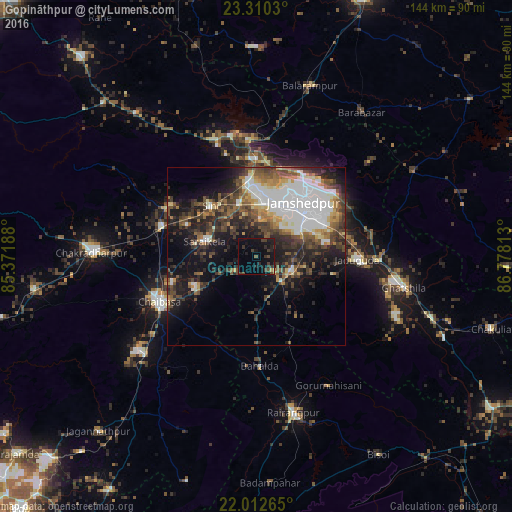
Analysis of Gopināthpur night lights 2016
Square area 10x10 km:
 0%
0%90-99
0%80-89
0%70-79
0.99%60-69
0.4%50-59
0.79%40-49
4.56%30-39
7.34%20-29
4.17%10-19
19.05%0-9
62.7%Square area 50x50 km:
6%90-99
5.36%80-89
2%70-79
2.43%60-69
2.74%50-59
4.31%40-49
5.3%30-39
5.86%20-29
7.9%10-19
12.35%0-9
45.75%Clear (daylight) street map image can be seen on geolist.org.
Map coordinates:
23° 18' 37.1" North, 85° 22' 18.8" East
22° 39' 46.8" North, 86° 4' 30" East
22° 0' 45.5" North, 86° 46' 41.3" East
Some cities around Gopināthpur sort by population:
• Jamshedpur
19.2 km =11.9 mi,  36°
36°
• Chāībāsa
30.6 km =19 mi,  245°
245°
• Jugsālai
16.8 km =10.4 mi, 41°
• Gobindpur
3.3 km =2.1 mi,  186°
186°
• Saraikela
15.3 km =9.5 mi,  285°
285°
• Kharsāwān
28.8 km =17.9 mi,  299°
299°
• Kāndra
21.1 km =13.1 mi,  353°
353°
• Sini
19.7 km =12.2 mi,  317°
317°
1270944 (p: 5,255)
Sources (retrieved 2019-11-25):
» Earth at Night: Flat Maps 2012, 2016