Kamalpur night lights from space
Night Light of Kamalpur (Tripura) from space (India) Src. Average luminocity for 10x10km area is 12.3409% and for 50x50km: 7.3458%.
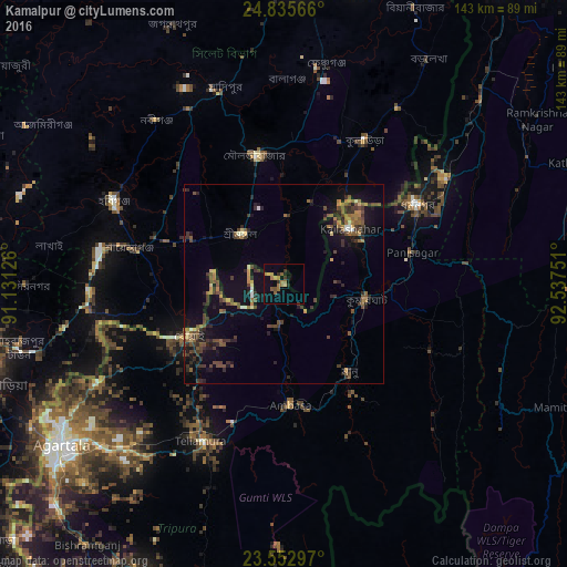
Analysis of Kamalpur night lights 2016
Square area 10x10 km:
 0%
0%90-99
0%80-89
0.76%70-79
1.52%60-69
6.06%50-59
2.84%40-49
1.14%30-39
1.89%20-29
2.08%10-19
4.17%0-9
79.55%Square area 50x50 km:
0.17%90-99
0.35%80-89
0.41%70-79
0.75%60-69
1.32%50-59
1.69%40-49
2.13%30-39
1.99%20-29
2.25%10-19
5.67%0-9
83.28%Clear (daylight) street map image can be seen on geolist.org.
Map coordinates:
24° 50' 8.4" North, 91° 7' 52.5" East
24° 11' 45.3" North, 91° 50' 3.8" East
23° 33' 10.7" North, 92° 32' 15" East
Some cities around Kamalpur sort by population:
• Habiganj, BD
47.4 km =29.5 mi,  295°
295°
• Maulavi Bāzār, BD
33.2 km =20.6 mi,  348°
348°
• Baniachang, BD
60.1 km =37.3 mi,  306°
306°
• Dharmanagar
38.7 km =24 mi,  60°
60°
• Kailāshahar
22.9 km =14.2 mi,  48°
48°
• Khowai
27.1 km =16.8 mi,  241°
241°
• Rānīr Bāzār
62.3 km =38.7 mi,  229°
229°
• Āmbāsa
29 km =18 mi,  175°
175°
1268271 (p: 5,508)
Sources (retrieved 2019-11-25):
» Earth at Night: Flat Maps 2012, 2016