Jodiya Bandar night lights from space
Night Light of Jodiya Bandar (Gujarat) from space (India) Src. Average luminocity for 10x10km area is 2.7718% and for 50x50km: 3.701%.
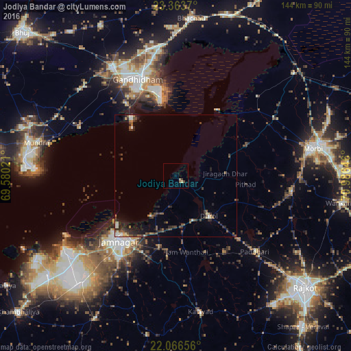
Analysis of Jodiya Bandar night lights 2016
Square area 10x10 km:
 0%
0%90-99
0%80-89
1.59%70-79
0%60-69
0%50-59
0.79%40-49
1.59%30-39
0%20-29
0%10-19
0%0-9
96.03%Square area 50x50 km:
0.21%90-99
0.45%80-89
0.29%70-79
0.22%60-69
0.31%50-59
0.99%40-49
0.91%30-39
1.05%20-29
1.34%10-19
1.72%0-9
92.52%Clear (daylight) street map image can be seen on geolist.org.
Map coordinates:
23° 21' 49.3" North, 69° 34' 48.8" East
22° 43' 0" North, 70° 16' 60" East
22° 3' 59.6" North, 70° 59' 11.3" East
Some cities around Jodiya Bandar sort by population:
• Jamnagar
35.1 km =21.8 mi,  219°
219°
• Gāndhīdhām
43.6 km =27.1 mi,  339°
339°
• Anjār
51.3 km =31.9 mi,  329°
329°
• Dhrol
21.6 km =13.4 mi,  140°
140°
• Kāndla
35.9 km =22.3 mi,  349°
349°
• Bedi
34.3 km =21.3 mi,  225°
225°
• Tankāra
48.3 km =30 mi,  98°
98°
• Paddhari
45.1 km =28 mi,  133°
133°
1268863 (p: 15,788)
Sources (retrieved 2019-11-25):
» Earth at Night: Flat Maps 2012, 2016