Hirekerūr night lights from space
Night Light of Hirekerūr (Karnataka) from space (India) Src. Average luminocity for 10x10km area is 8.4264% and for 50x50km: 3.865%.
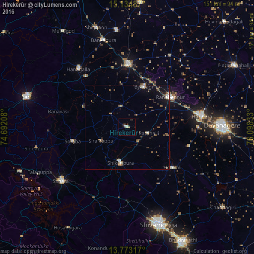
Analysis of Hirekerūr night lights 2016
Square area 10x10 km:
 0%
0%90-99
3.25%80-89
0.65%70-79
1.3%60-69
0%50-59
0.43%40-49
0.87%30-39
3.03%20-29
2.16%10-19
0%0-9
88.31%Square area 50x50 km:
0.17%90-99
0.63%80-89
0.28%70-79
0.42%60-69
0.47%50-59
0.82%40-49
0.72%30-39
0.63%20-29
1%10-19
2.08%0-9
92.78%Clear (daylight) street map image can be seen on geolist.org.
Map coordinates:
15° 8' 5.5" North, 74° 41' 31.5" East
14° 27' 18.2" North, 75° 23' 42.7" East
13° 46' 23.4" North, 76° 5' 54" East
Some cities around Hirekerūr sort by population:
• Rānībennur
31.3 km =19.4 mi,  53°
53°
• Hāveri
37.6 km =23.4 mi,  1°
1°
• Shikārpur
21 km =13 mi,  191°
191°
• Byādgi
26.2 km =16.3 mi,  22°
22°
• Honnāli
36 km =22.4 mi,  131°
131°
• Nyāmti
39.3 km =24.4 mi,  150°
150°
• Sorab
33.7 km =20.9 mi,  255°
255°
• Kumsi
44.5 km =27.7 mi,  179°
179°
1270036 (p: 16,688)
Sources (retrieved 2019-11-25):
» Earth at Night: Flat Maps 2012, 2016