Chāndūr night lights from space
Night Light of Chāndūr (Maharashtra) from space (India) Src. Average luminocity for 10x10km area is 7.252% and for 50x50km: 9.8344%.
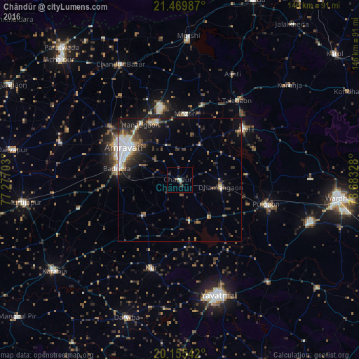
Analysis of Chāndūr night lights 2016
Square area 10x10 km:
 0.99%
0.99%90-99
0.99%80-89
0.4%70-79
0%60-69
1.59%50-59
0.79%40-49
0.6%30-39
2.18%20-29
3.37%10-19
1.39%0-9
87.7%Square area 50x50 km:
1.89%90-99
1.34%80-89
0.51%70-79
0.63%60-69
0.97%50-59
1.77%40-49
1.64%30-39
2.38%20-29
3.19%10-19
5.37%0-9
80.33%Clear (daylight) street map image can be seen on geolist.org.
Map coordinates:
21° 28' 11.5" North, 77° 16' 37.3" East
20° 48' 50.7" North, 77° 58' 48.5" East
20° 9' 19.5" North, 78° 40' 59.8" East
Some cities around Chāndūr sort by population:
• Amrāvati
27.3 km =17 mi,  299°
299°
• Yavatmāl
49.4 km =30.7 mi,  161°
161°
• Ārvi
32.8 km =20.4 mi,  51°
51°
• Morsi
58.6 km =36.4 mi,  3°
3°
• Pulgaon
36.8 km =22.9 mi,  106°
106°
• Dārwha
60.1 km =37.3 mi,  201°
201°
• Dattāpur
17.1 km =10.6 mi,  102°
102°
• Deoli
55.1 km =34.2 mi, 109°
1274675 (p: 19,163)
Sources (retrieved 2019-11-25):
» Earth at Night: Flat Maps 2012, 2016