Bomdila night lights from space
Night Light of Bomdila (Arunachal Pradesh) from space (India) Src. Average luminocity for 10x10km area is 3.6856% and for 50x50km: 0.5998%.
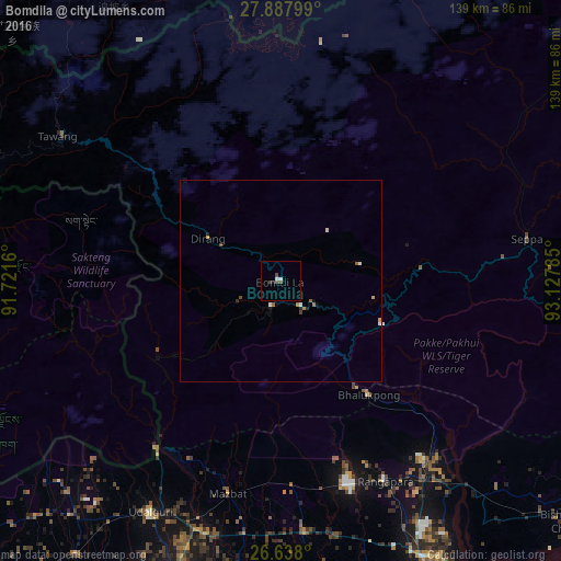
Analysis of Bomdila night lights 2016
Square area 10x10 km:
 0.76%
0.76%90-99
0.76%80-89
0%70-79
0%60-69
0%50-59
0%40-49
2.46%30-39
0.57%20-29
0.19%10-19
0.57%0-9
94.7%Square area 50x50 km:
0.09%90-99
0.09%80-89
0.05%70-79
0.08%60-69
0.1%50-59
0.08%40-49
0.19%30-39
0.05%20-29
0.05%10-19
0.14%0-9
99.08%Clear (daylight) street map image can be seen on geolist.org.
Map coordinates:
27° 53' 16.8" North, 91° 43' 17.8" East
27° 15' 53.1" North, 92° 25' 29" East
26° 38' 16.8" North, 93° 7' 40.3" East
Some cities around Bomdila sort by population:
• Tezpur
79.5 km =49.4 mi,  152°
152°
• Dhekiajuli
62.6 km =38.9 mi,  175°
175°
• Dhing
88.7 km =55.1 mi, 176°
• Rangāpāra
53.3 km =33.1 mi, 153°
• Khārupatia
87.4 km =54.3 mi,  198°
198°
• Udalguri
65.2 km =40.5 mi,  209°
209°
• Trashi Yangtse, BT
99.2 km =61.6 mi,  292°
292°
• Trashigang, BT
86.3 km =53.6 mi,  275°
275°
1275334 (p: 7,121)
Sources (retrieved 2019-11-25):
» Earth at Night: Flat Maps 2012, 2016