Bijrauni night lights from space
Night Light of Bijrauni (Madhya Pradesh) from space (India) Src. Average luminocity for 10x10km area is 0.4318% and for 50x50km: 2.4613%.
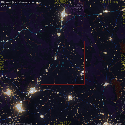
Analysis of Bijrauni night lights 2016
Square area 10x10 km:
 0%
0%90-99
0%80-89
0%70-79
0%60-69
0%50-59
0%40-49
0%30-39
0.76%20-29
0%10-19
0%0-9
99.24%Square area 50x50 km:
0.05%90-99
0.39%80-89
0.24%70-79
0.21%60-69
0.25%50-59
0.51%40-49
0.57%30-39
0.76%20-29
0.66%10-19
0.66%0-9
95.7%Clear (daylight) street map image can be seen on geolist.org.
Map coordinates:
25° 34' 8" North, 76° 56' 25.4" East
24° 55' 58.7" North, 77° 38' 36.7" East
24° 17' 37.4" North, 78° 20' 47.9" East
Some cities around Bijrauni sort by population:
• Shivpuri
54.6 km =33.9 mi,  1°
1°
• Guna
46.2 km =28.7 mi,  226°
226°
• Ashoknagar
40.7 km =25.3 mi,  167°
167°
• Chanderi
55.6 km =34.5 mi,  116°
116°
• Bāmor Kalān
51.4 km =31.9 mi,  94°
94°
• Kolāras
32 km =19.9 mi,  354°
354°
• Badarwās
9.2 km =5.7 mi,  300°
300°
• Isāgarh
26.3 km =16.3 mi,  113°
113°
1275674 (p: 5,743)
Sources (retrieved 2019-11-25):
» Earth at Night: Flat Maps 2012, 2016